

“A canvas awaiting…”
This week is the 10 year anniversary of a life-changing trip to a golf course far away and lost in time: Askernish. To both reflect upon it as well as occupy my time during this pandemic crisis, I am rolling out a multi-part series that explores my thoughts, emotions, and lessons learned from a legendary week on the links. This is Part 2, a look at a wildly fun exercise in which we hypothetically route nine holes over virgin links land, playing by the same rules that Old Tom Morris would have.
Day 2
Have you ever traveled somewhere new and arrived in the darkness of night? Remember what it was like to wake up the next morning and see a brand new scene and landscape?
It is a completely different sensation from traveling and arriving by day, where the landscape and scene slowly morphs and changes to the one that awaits you at your final destination. Instead of a slow buildup, it’s more like going into a theatre and having them pull up the curtain not to reveal the stage but rather the new world you’ve ventured to. It’s intense, wonderful, and fleetingly exciting. It’s like waking up on Christmas morning and opening every present at once.
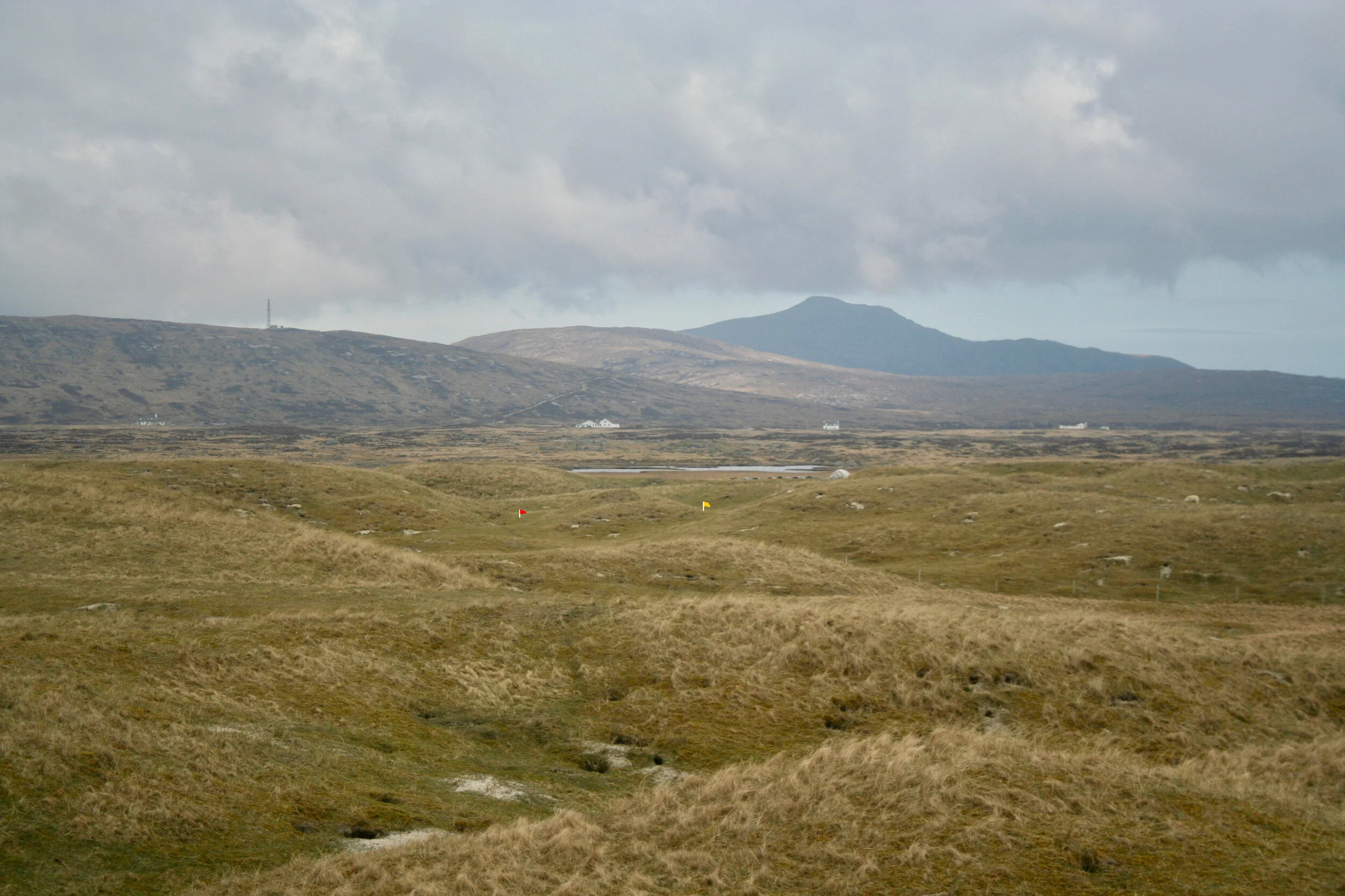
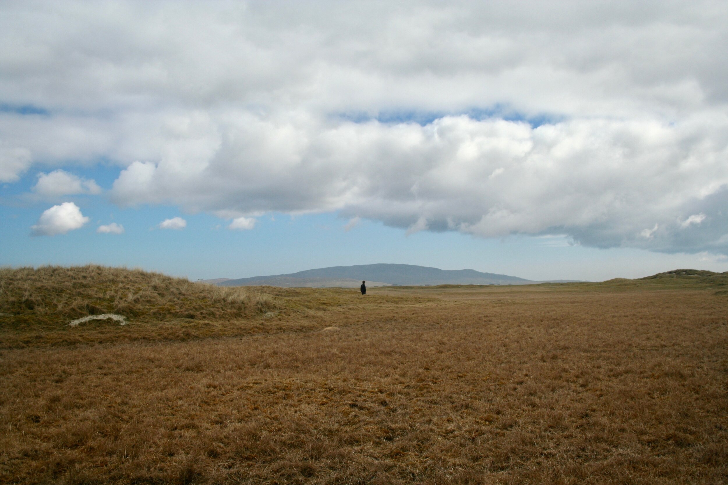
My first daylight reveal of Askernish was no different. Out my bedroom window, there it all was, basking in yet another golden sun and deep blue sky. The great grazing plain of the machair is broad and low-lying, dipping down to ground water levels in many places before rising back up into the heaving dunes along the beach. Colors and textures are varied, sheep are quite present, structures are few, and trees are completely non-existent—the soil too poor and typical wind far too strong to support any of them. There was no wind though on this exceptionally pleasant day.

The machair and links waiting to be explored. The small white building is the Askernish clubhouse.
We started off the week with an incredibly fun task that was very on point with my intended career: routing 9 holes over virgin links land just to the south of the golf course. Martin Ebert of MacKenzie & Ebert International Golf Architects was our instructor for the two day assignment. He was also the lead architect that helped to find the Old Tom Morris routing, or at least route/design the course just as Old Tom would have. This meant simply finding the key features and green sites as they were in the ground. Outside of some handwork to build small tee grounds, this meant no earthmoving. Instead, it was simply just mow it down, and on ye go—play away. For this service, Martin charged a handsome design fee of 9 GBP, the same amount that Old Tom charged back in his time.
How close this version of the course is to Old Tom’s time can never be completely proven, but what is left is an extremely fun, tumbling, varied routing that harkens back to when golf truly was an adventure. Knowing that, this routing exercise with Martin was going to be a lot of fun.
The clubhouse: somewhere between 2000-6000 years old
We were teamed up into groups of 2, myself being paired with Toby, the South African. Our constraints were simple—stay south of the existing Askernish course and assume a locked-in clubhouse site that also happened to also be a prehistoric ruin of a small village. Maybe it’s just the American in me with our really old stuff being 200-300 years old, but when I come across something that humans built before Jesus’s time, I kind of freak out a little. This place just continues to amaze in both its beauty and its history.
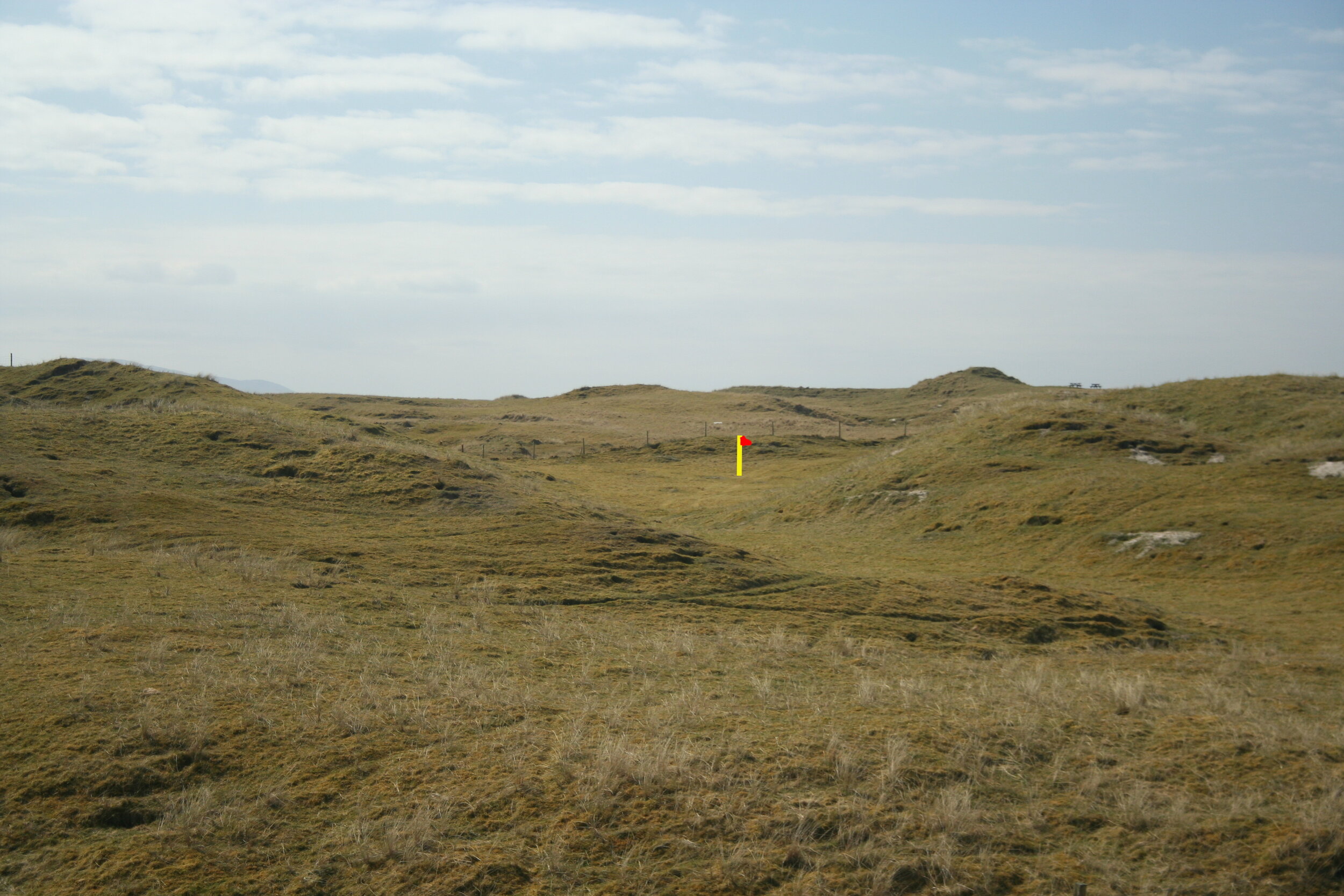
Toby and I set off in search of golf holes, which were not hard to find. I always liked the notion of a routing being the way you might instinctually walk the ground of a property. With that, we headed straight toward the beach and ocean in a northwesterly direction. There was a fun short par four to be had it seemed and would serve as a fun and beautiful opener. Our instinct was to tuck the green between the beach access road, which was just sand, and a tall dune. This would leave us with a very short opener of about 260 yards and an early decision to make—go at this green or lay back? It would actually be a tough one to pull off due to both the road crossing and the prevailing wind in the face, but I’m sure many would enjoy at least trying. Even though the green is a bit shallower between the dune and road from the left, that is probably the better angle because the green is more receptive from that direction. I don’t necessarily love a forced carry on the opening hole, but it plays a short length, The Old Course does the same thing, and there would be plenty of ground game shots to come during the rest of the round, including at the next hole.

View from the fairway of the short par 4 1st. This is one of the few spots that the dune ridge is low enough to see the ocean. The yellow and red flag has been added to indicate the approximate location of the green.
Heading to the beach and northward also allowed us to easily utilize the narrower, but highly desirable, property between the “clubhouse” and the north border. The ground going back inland from just north of the first green was some of the choppiest dune land available to us, but it was not so extreme as to be unplayable. Not having a hole or two in here would be a real missed opportunity. From a bluff edge over the beach that made a nice spot for a tee, we just walked out into the dunescape without any ideas of par or yardage, instead waiting for an ideal green site to appear. And one did. A wild one.
Tucked in a shallow dell flanked by two large dunes, our green had a large, pointy mound fronting it, which left two “V” slots to its left and right. Some days you would get a peek at the flag on the left and play down that side of the hole. Some days you would see it on the right and favor right-center. Other days you might not even see it at all and assume it is smack dab behind the mound, in which you want to play to the far outsides of the fairway to get a clear shot. Failing that, you’d want to hit a running shot off one of the outsides of either V in order to work it around the mound. No matter what, the hole presents fun and unusual challenges and is a highlight even without the beauty and drama of the ocean.
Left and right flags visible through the “V” slots but still half hidden due to the fallaway bowl that is the green.

Hole 2 from 200 yards in. This rendering shows the variety of shots that can be played off and through the fronting slopes.
We followed up with a nice little naturally-sitting par 3 with some foreground dunes criss-crossing and framing the green. The green sat nicely in a low with medium contour and a strong back to front tilt, which set it apart from the previous fallaway green. The intimate setting of the hole had a very good feel that was different from the rest of the routing.


After that was one of my favorite holes: a simple yet highly strategic par 4 down into a valley where the road to the beach ran through. This design exercise was all about using what you have, and I intended to use this road, which was sandy and sharply walled in most places—effectively making it a very long narrow bunker—to my advantage. With a slight diagonal, it was a no brainer to place the green tight to it on the opposite side and force a crossing at some point. That crossing could come with an aggressive play off the tee, clearing the hazard or at least nuzzling up very close to it to get the better, longer angle down the green. Or it could come on the second shot from down the left on the safe-line, but that leaves a partially blind shot over the road to the green that is just about impossible to hold on the putting surface. This was effective, fun strategy just using a simple access way.
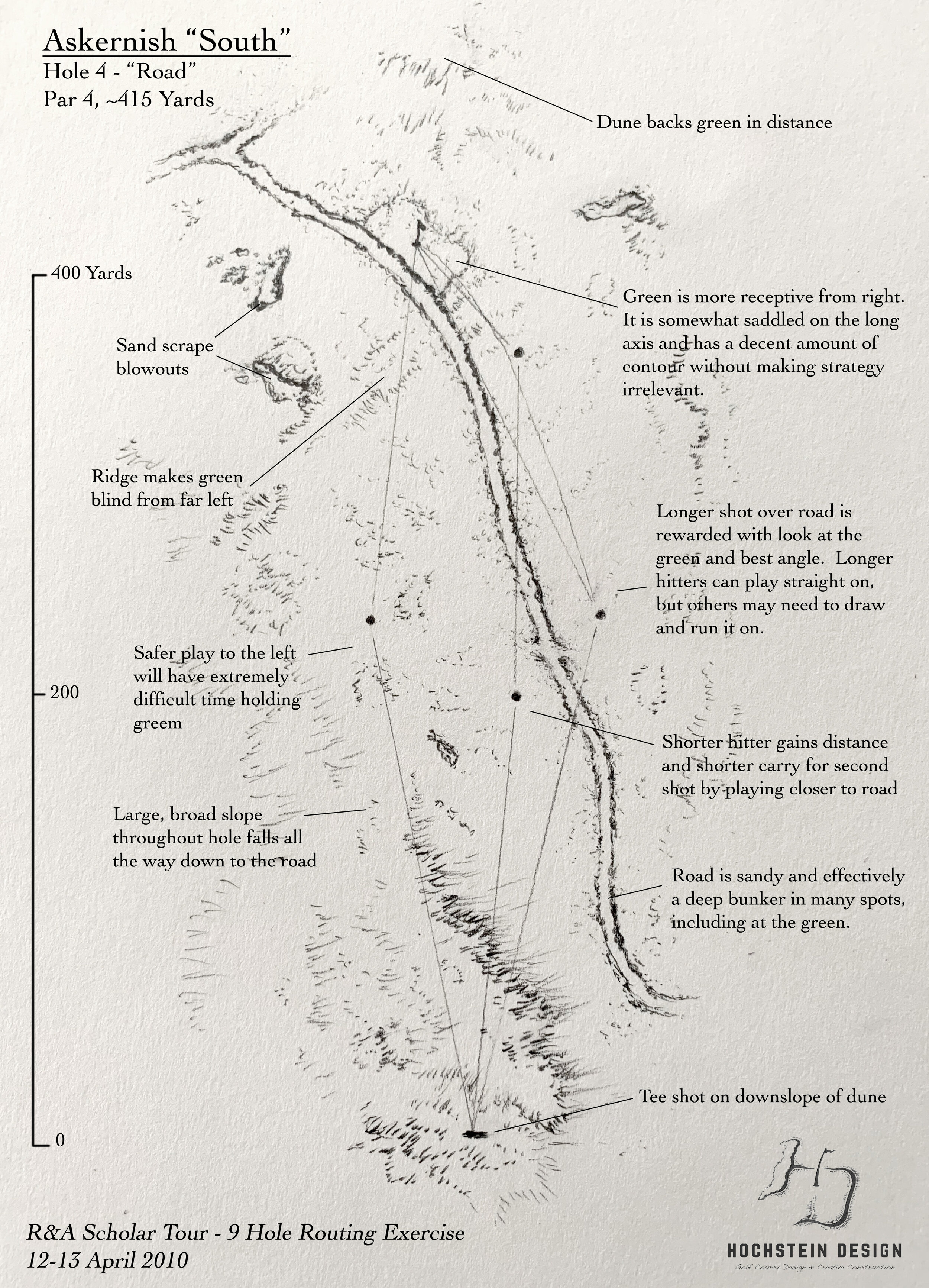
Diagram of hole 4 showing the optional routes of play. The road must be crossed at some point. The question for the player is “when?”


The 5th was a hole that in truth was probably not possible because during that week we were seeing it in a different light. A large majority of it sat in a seasonal floodplain where groundwater would breach the surface at times of heavier rain. It was completely dry though when we saw it, and what we saw was also a very interesting and strategic golf hole.
The tee shot played off a dune down into a broad, low lying flat. In the foreground, there was a medium sized dune to clear. In the distance, views of habitations. In the middle of the hole, a large, pesky mound that must be dealt with. That dune-mound acts like a center-line bunker, dictating play and strategy, especially as we placed the green halfway behind another dune mound further down the hole. This greenside mound isn’t too dissimilar from the hill guarding the 16th hole at Lundin Links, which is the inspiration for Charles Blair MacDonald’s “Leven” template. I knew little of that hole or the Leven template at that time, but I knew that this would be a brilliant spot for the green here. It would guard all play from the left side of the hole. Any shot that clears it will have a hard time holding the green and run on for quite a ways on the flat firm ground; any that lands short is likely to end up hung up in the shaggy grass of the dune. Tee shots that take the longer, narrower route out to the right of the centerline mound, however, will be met with an open view of the green and a chance to bump and run it on. It’s very much an inverse of the second hole at Pacific Dunes, except instead of bunkering it uses mound-y dunes as the guarding hazards. Again, this is effective, fun strategy with no artificiality or man’s imposition attached.

A simple mound and well-placed green provide all the interest on the 5th hole.


Hole 6 was where it really starts to get into that old time-y links territory. The tee sits in the middle of a vast, grazed-down flat area. You really could put it anywhere you wanted. As such, we didn’t place it until walking the entire hole and figuring out what everything was and where the green would be. What was certain either way was that the tee shot would be blind over a low lying ridge and play out to a generally flat field slowly rising upward toward the dune ridge at the edge of the beach. One problem awaits though, especially for the big hitter—a large, blind sandy blowout that resembled a slightly smaller version of the original Hell Bunker at the 14th at St Andrews. It was rugged and penalizing, and with that we decided that the green should lie directly beyond it at the toe of the beachside dunes. For most players, it would be unreachable, especially against the prevailing westerly wind, but for the aggressive hitter trying to get close (or being careless), finding it could ruin the hole. In the most severe winds, the bunker may actually come into play on the second shot, and that is where it may get the most interesting. Do you go left, right, or over it? It all depends on the circumstances, which in a nutshell is the beauty of links golf. Whereas the previous two holes have strategic quirk, this one has more of just the odd, “it is what it is” quirk you find at some old links, where there was no other good way to connect holes or alter the land to make it better. The weather, the seasonality, the turf, and your own play all provide the variety and interest, which can be different every time you play. And that’s what makes links golf, and holes like this odd one, so enduring.


From the 6th green, it was time to go say hi to the Ocean again. It was too obvious and easy to climb up the ridge and put the tee right on the edge of the bluff, leaving a 360 degree view with the white beach and bright blue, Caribbean-like water on one side and the machair and distant mountains on the other. It was brilliant and beautiful stuff.
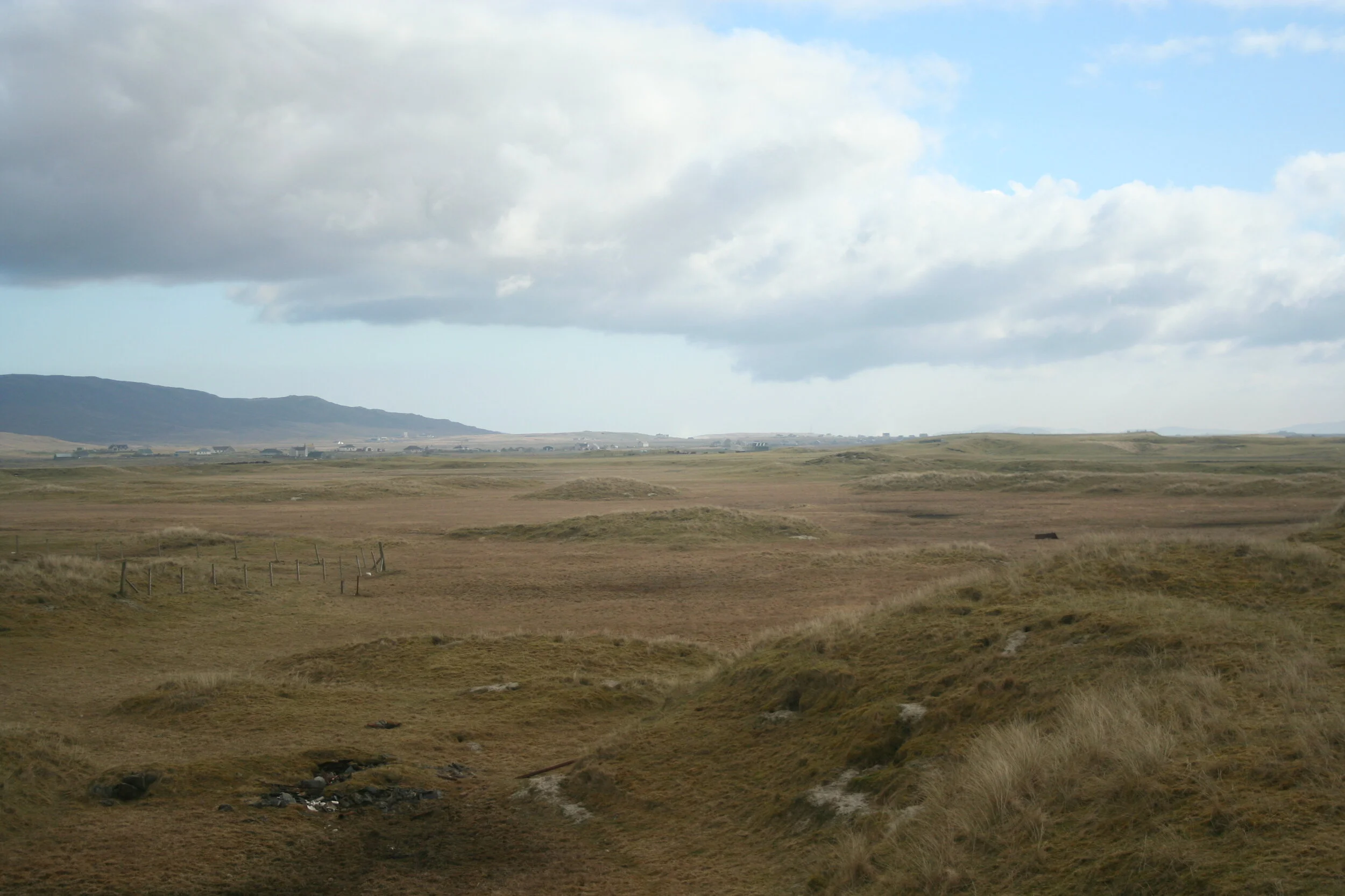
This also happens to be the part of the round where my memory, and the routing itself, gets less clear. From this furthest point away from the clubhouse, we had a few options for how to get back there. We could turn back inland at a 45 degree angle and play toward a some dunes and a blowout, then either work our way back toward the beach and up to the clubhouse or just go back to the clubhouse. Or we could ride along the coast and the dune ridge there. Either way, a big stretch of pretty benign land had to be crossed.
Luckily, we still had the first part of the morning to figure it out before doing our walk throughs with Martin. For now, it was time to go in for supper.
Day 3

The view away from the golf on the 7th tees isn’t too bad at all
‘Twas another bonnie day out on the links upon waking, and I wanted to quickly get back out and figure out the rest of these holes before doing the walk through. Even though I can’t completely remember the final 3 holes in full detail, here’s what I think happened:
We made a par 3 for the 7th playing down and slightly away from the beach ridge. There was some interesting ground there for a green site but not much for a ways beyond, so this made sense. I can’t help but think that the 10th hole at North Berwick was in the back of my mind too, because spatially this felt exactly like that. We reach the farthest point on the property after crossing flatter ground, go up to the ridge to place a tee with a view of the sea, and play down to a par 3 at nearly the same angle from the beach as North Berwick 10. This green though is a bit more receptive than that one with a dune bank up the left and some smaller support on the right. A bump in the left ridge allows the green to go around it and have some truly tucked holes in the back left. In that way, it’s actually not too different from some William Watson greens we’ve worked on at Orinda and Diablo.


From there, we finally get a par 5. We set the tee behind the dune next to the green to hide it, but like number 6, there is plenty of elasticity and open ground to lengthen the hole or change the angle. What doesn’t change though is the finishing half of the hole, which plays right along the beach in a long, rumply sort of half pipe. To get into that half pipe though and have a view at the green requires an uneasy blind second shot over a ridge and into it. Add to that what is likely to be a strong left to right wind off the Ocean, and the shot is even more difficult. The payout for finding it is good though, and those 2nd shots that reach it will be rewarded with a view of the green and the option of keeping the ball on the ground and out of the wind, those running shots corralling in a friendly way off the sides of the flanking ridges as they tumble up to the bowl-like putting surface.
The final hole again gets a bit weird, as we kind of got stuck. I’m pretty sure it was a blind shot over some severe dunes and pits, one of which has the shell of an old burned car at the bottom of it. If you carried all that though, you ended up at a pretty friendly green in a bowl up near the clubhouse site. Really though, holes like these are in the spirit of links golf, especially that in the west of Scotland. Prestwick, Shiskine, and others all have odd connectors like these, and many of them are a lot of fun, creating that excitement to run up to the top of the hill and see where the shot ended up. This would be no different from that.
In truth, this section of the links near the “clubhouse” was always going to be tough to figure out. A lot of it is a higher plateau with extremely deep valleys. Golf doesn’t really “work’ for much of it, which is a bit frustrating since it is otherwise interesting compared to the broader flat areas. We are doing this like it’s 1890 though, so it stays as it is. And really, that’s probably all for the better. Grab your mid-iron, bash on, and pray to ye gowf gods!


———

Our routing as laid over satellite imagery. The light blue lines indicate a less-advantageous alternate route.
We did the walk throughs with Martin and eventually came to ours. He thought there was some interesting stuff but was also concerned about back to back short holes to open as well as overall length. I could see that point and thought of a few ways to remedy it, but I really liked the green sites and some of the strategy. I also was embracing the old school, golf-as-adventure spirit and just wanted there to be interesting shots and situations.
If I had a self criticism though, it would be that I don’t know if I maximized usage of the most dramatic dune areas or the beach frontage. Could there be more holes in those dunes, and did I venture out too far with 5 and 6? Could I have had some greens that had ocean views? Could I have done something interesting and quirky with the cemetery? What would I have done differently if I had known hole 5 would be unplayable for part of the year? I actually sought to remedy a few of these things with some free time later in the week and came up with a mostly different routing. Unfortunately though, both my notes and memories of that have been lost, only some barely-descript photos of unmarked links land giving me vague and frustrating clues as to what I was thinking. I guess that just means I have to go back there and figure it out.
I also still don’t love how the final hole ended up, and I think there is a good par 5 that could come in at a 90 degree angle to the same green site that we ended up with. You would end up losing the 8th though, which is a pretty interesting par 5 close to the ocean. This kind of push-and-pull is the fun though as well as the challenge of golf course routing. There are way more than 18 potential holes out there (or in this case, 9), and the best architects figure out how to parse out the best final combination that balances flow, experience, strategy, and overall quality. Sometimes that means sacrificing one great hole to elevate three other ones. Sometimes it means breaking convention, like Pacific Dunes’ back to back par 3s, to get the best overall quality. These decisions are all critical. So, was my routing the best it could be? Probably not. After all, it was my first time really doing it on the ground, and it was only over a day. With more time to walk the ground as well as the experience gained from 10 more years of studying and living golf, another crack at it would surely be better. That might just have to be a different post though for another day…
Day 3 will be continued in the next part of the series—Askernish After 10 Years: The Golf Course.
Below: images the author, Martin, and the group walking the land and finding golf holes.


